Back on the Isles of Scilly
By the time we had finished setting up the tent, I was pretty tired. Had a pleasant stroll along the beach to relax and slip back into the relaxed ‘Scilly’ life – “Ah that’s better…”
I am using a sketch pad with thick watercolour paper in it and I have my usual sketching things. Travell watercolour set, 6B pencil and black sketching pens.
Pen & Watercolour ~ A4
Sketching at Rushy Bay on Bryher, looking out to the uninhabited island of Samson.
St Mary’s

Weather was drizzly and overcast today, so we crossed over to St Mary’s, for a look around the ‘busy’ metropolis of Hugh Town. With the rain lifting, we are sat on Porth Cressa beach, eating our lunch and sketching.

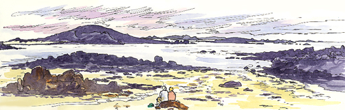
Sketching on ‘Voyager’. The St Martins ferry. Here are the islands of Great Arthur and St Mary’s as seen from in the middle of Crow Sound.
St Martin’s

Sheltered Higher Town Beach
Watercolour ~ A4
Sketch showing the moored boats in the choppy waves, with the islands of Nornour & Great Ganilly in the background.
Wind & rain in the night lashed down on our tent. However, this morning we are left with the boisterous wind, but a lovely sunny day. We are sending the day exploring St Martin’s today. We found a sheltered spot on Higher Town Beach to eat our lunch, which we had bought from the excellent bakery.
Feeling refreshed we walked around Chapel Downs, where the north wind was pushing the breakers hard into the rocks below the cliffs. Although the Blackback Gulls did not seem to mind, as they rode the wind. We also saw four seals in the bay and a shoal of fish in the seaweed.
We are sat below the Daymark, the highest point on the island. It looks like a red & white rocket sticking out of the ground – you can’t miss it!

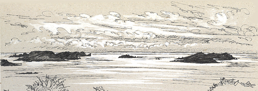
Wave tossed St Martin’s Bay
Watercolour with a pen ~ A5
Sketching St Martins Bay (below), the fresh breeze is driving in the incoming tide. Burnt Hill is on the left, with Murr Rock on the right and White Island behind them.
The little island of Tean
Taking things easy today – as they should be, when on Scilly. Mostly sunny & warm, but with a little drizzle at lunchtime. Sat here on the west of St Martins sketching the beautiful little island of Tean. A4 ~ Watercolour.


St Agnes
Bound for St Agnes this morning, over a glassy still sea.
Each of the Scilly Isles has its own atmosphere and feel to it. St Agnes seems more windswept and remote from the others.
It is thought that at one point (around 400-500 AD) the Isles of Scilly were one landmass, called ‘Ennor’. St Agnes and Gugh (its sister island) were probably the first large island to split away from this island. As the channel between it and St Mary’s is relatively deep, compared with the rest of the larger islands.
We had a smashing day exploring parts of St Agnes that we hadn’t seen before.
Bishops Rock Lighthouse

Pen with watercolour washes ~ A5
This sketch shows the fearsome Western Rocks with the Bishop Rock Lighthouse on the horizon. They are looking very calm today.
Gigs

Later I was sitting outside the Turks Head sketching the Pilot Gigs. That are rafted together, in Porth Conger. Their crews having a well-earned pint, after their race.
To the Daymark
This morning was the lowest tide of the year. There was quite a buzz going around St Martin’s Campsite. That you could walk to the little islands that are usually inaccessible.
With most of Scilly being one large island, not too long ago and because of that Crow Sound is fairly shallow.
So we set off across St Martins Flats (that is usually underwater) to see how far we could get. It was interesting looking and walking across what was a sea bed. We crossed to Moths Ledge, Guther’s Bar and stood on top of Guther’s Island, halfway to St Mary’s. Guther’s Island was mostly covered in bird poo – not surprisingly. From here you could see the sand bar heading on to St Mary’s underwater. Apparently, the route on to St Mary’s has been waded on such a tide. The man who managed it just keeping his nose above the water!
On getting back we had lunch and then set out for Higher Town Bay and sat there sketching.

Path to the Daymark
Watercolour & Pen ~ A4
Showing one of the paths that lead up towards the Daymark. I like the curve of the wall, as it undulates along.

Crow Sound
Watercolour & Pen ~ A4
Another sketch, from the same place, looking the other way. With clouds streaming across the sky and the boats heading out from the little quay across Crow Sound. We had been strolling about out there earlier!
Around the coast of Bryher
Another fantastic sunny day and we are off, taking the boat over to Bryher. Which we haven’t visited for two years and that’s two years too long.
Bryher always seems such a peaceful little island. The name in Cornish (Breyer) means ‘place of hills’. We looked into the church for the first time – it was not open before. Which was lovely, with beautiful stained glass and oil lamps as the lighting.

Gweal Neck
Watercolour ~ A4
This sketch is of the island of ‘Gweal’ off Bryher’s eastern side. Looking through the Gweal Neck (the tidal channel) out onwards to the Northern Rocks.
Finally – Breakfast with a view
Pen + white gouache ~ A4
I have now run out of pages in my sketchbook, so this last one is drawn on the card at the back of the book. I used white paint for highlights. It gives the effect of coloured pastel paper that I rather like.
Strolled up to Higher Town bakery for a breakfast of croissants, which we then ate sat on the beach. This is our last morning on St Martins – Boo, Hiss!
Sitting quietly, looking out across Higher Town Bay, towards the Eastern Isles and the way we will soon be heading.
Right then, time to strike camp.
© Copyright Nick Watton.
All Rights Reserved.
